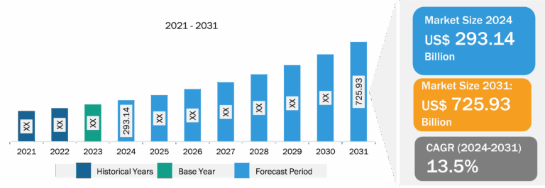
Geographic Information System (GIS) Market
The key players operating in the geographic information system (GIS) market include Autodesk, Inc.; Topcon Positioning Systems, Inc.; Caliper Corporation; SuperMap Software Co., Ltd.; Hexagon AB; Hi-Target; Pitney Bowes Inc.; Maxar Technologies; AmigoCloud, Inc.; Trimble Inc.; Bentley Systems, Incorporated; Cadcorp Limited; Spatialworks Sdn Bhd.; Environmental Systems Research Institute, Inc.; Blue Marble Geographics; Abaco SpA; TomTom International BV; FARO Technologies, Inc.; L3Harris Technologies, Inc.; and Başarsoft Information Technologies Inc. are few major players in the market.
High Demand for Real-Time Location-Based Services in Logistics and Transportation and Infrastructure Sectors
The global logistics industry was valued at ~US$ 9.4 trillion in 2023 and is expected to reach US$ 9.9 trillion in 2024, with an annual growth rate of 5.3%, according to the United Nations Report in 2022. In the transportation and logistics sector, geographic information system is used for live traffic monitoring and real-time vehicle tracking. GIS offers monitoring functions using visual display of the spatial data and provides precise geographical real-time positioning of monitored vehicles. Also, GIS mapping solutions are widely used to create new railway routes, roadways, and other transportation routes. Investments in the infrastructure development of roadways and railways across the globe continue to grow rapidly. According to the Global Infrastructure Outlook Report, in 2023, the global transportation infrastructure investment reached US$ 1.60 trillion. Geographic information system is widely used in the analysis and visualization of spatial data while planning transportation infrastructure and management.
Geographic Information System (GIS) Market Analysis: Component Overview
The geographic information system market is segmented by component into hardware, software, and services. The hardware segment held significant market share in 2023, owing to the increasing demand for hardware solutions across several industries, including military, construction, energy, and utilities. For instance, Aegean Energy Group has used the geographic maps using geographic information system to improve the construction of alternative energy and related operations. The company extended its capability of mapping by offering geographic information system (GIS) tools to streamline the field. The company offers data collection and provides location-based analytics services. Aegean Energy adopted various GIS hardware for wind and solar energy to meet the challenging obstacles, such as civil, safety, and environmental issues.
Geographic Information System (GIS) Market: Competitive Landscape and Key Developments
Autodesk, Inc.; Topcon Positioning Systems, Inc.; Caliper Corporation; SuperMap Software Co., Ltd.; Hexagon AB; Hi-Target; Pitney Bowes Inc.; Maxar Technologies; AmigoCloud, Inc.; Trimble Inc.; Bentley Systems, Incorporated; Cadcorp Limited; Spatialworks Sdn Bhd.; Environmental Systems Research Institute, Inc.; are among the key geographic information system (GIS) market players profiled during this study. In addition, several other important geographic information system (GIS) market players have been studied and analyzed during the study to get a holistic view of the geographic information system (GIS) market and its ecosystem.
| Year | News | Country |
| October-2024 | Blue Marble Geographics announced the immediate availability of the Global Mapper version 26.0 software development kit (SDK). The Global Mapper SDK provides software developers with access to the same industry-leading libraries used for Global Mapper and Global Mapper Pro. With this toolkit, users can leverage Blue Marble Geographics’ development efforts in their own applications, providing their customers with rich file format support, high-powered analysis tools, and high-speed visualization capabilities. | Global |